Boundary Survey

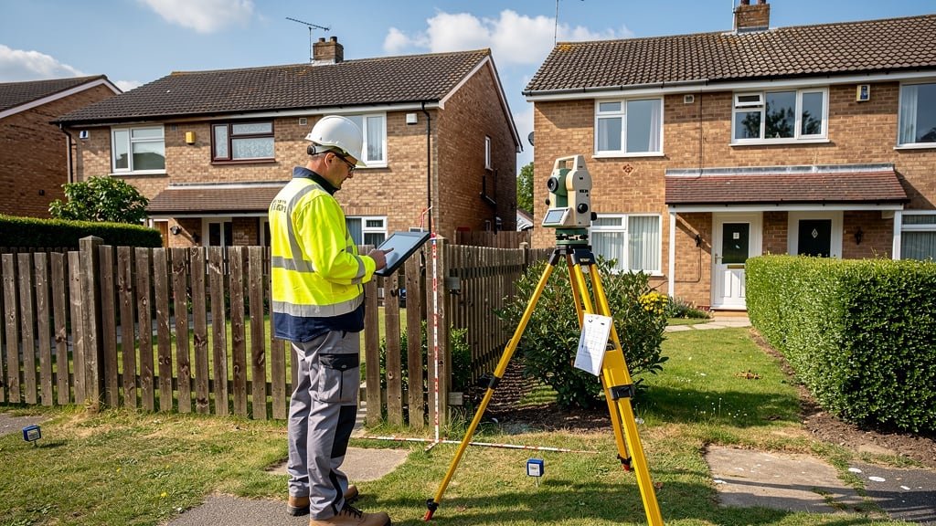
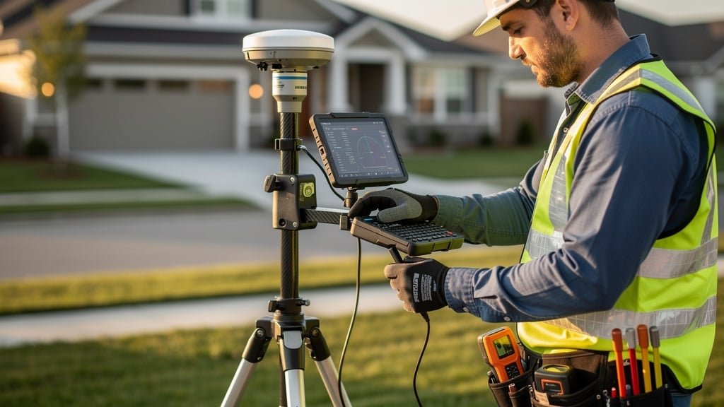
My Boundary Dispute Surveyors provide detailed boundary surveys to determine the exact position of your property boundaries. Our RICS-accredited chartered land surveyors use advanced surveying equipment combined with comprehensive research of Land Registry title plans, Ordnance Survey mapping, and historic boundary documents.

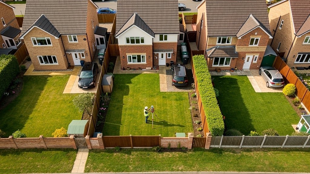
A boundary survey is essential when you need to understand where your legal boundary lies. Whether you're planning construction work near a boundary, dealing with a boundary dispute with your neighbour, or purchasing a property, our measured surveys provide the clarity you need.

What's Included in Our Boundary Survey

  • Detailed site visit and measured survey of all boundary features
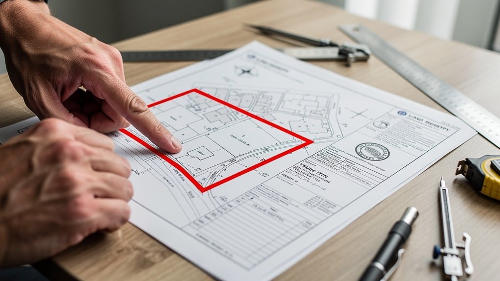
  • Analysis of Land Registry title plan and title deeds
  • Review of historic Ordnance Survey mapping
  • Examination of conveyance documents and property deeds
  • Identification of physical boundaries including fences, hedges, and walls
  • Comprehensive boundary report with our professional findings
  • Scaled drawings showing boundary position
  • Expert recommendations for boundary determination if needed

How Our Boundary Survey Process Works

Our chartered surveyors begin by reviewing all available documentation including your Land Registry title, historic maps, and any relevant conveyance documents. We then conduct a thorough site survey using GPS equipment and laser measurement tools to map the exact position of boundary features on the ground.

The boundary report we deliver explains how the physical boundaries relate to the legal boundary shown on your title plan. We consider the general boundaries rule applied by HM Land Registry and provide clear guidance on where we believe the boundary lies based on all available evidence.

Request Boundary Survey

Chartered surveyor conducting boundary survey with professional equipment
Neighbours resolving boundary dispute with professional surveyor assistance

Boundary Dispute Resolution

When a boundary dispute occurs, emotions can run high and relationships with neighbours can become strained. My Boundary Dispute Surveyors specialize in helping property owners resolve boundary disputes without costly legal action. Our experienced surveyors provide objective, professional boundary reports that help both parties understand the true position of the boundary.

Many boundary disputes arise because the general boundaries rule means Land Registry title plans do not show exact boundaries. This creates uncertainty that can lead to disagreements over fence positions, hedge ownership, or building encroachment. Our chartered land surveyors bring clarity to these situations through detailed analysis and professional expertise.

Our Dispute Resolution Approach

  • Independent, unbiased assessment of the boundary position
  • Review of both parties' Land Registry title plans and deeds
  • Historical research into previous conveyances and boundary agreements
  • Detailed measured survey of existing boundary features
  • Professional boundary report useful to identify the correct boundary line
  • Guidance on reaching an agreed boundary with your neighbour
  • Support with boundary agreement registration at Land Registry
  • Expert witness services if legal action becomes necessary

Benefits of Professional Dispute Resolution

Our boundary reports have helped hundreds of neighbours reach an agreement without going to court. By providing factual, professional evidence about where the boundary lies, we create a foundation for constructive discussion. This approach saves thousands in legal costs and helps preserve neighbourhood relationships.

If your boundary dispute cannot be resolved through agreement, our RICS-accredited surveyors can provide expert witness testimony and support you through the Land Registry determination process or court proceedings.

Get Dispute Resolution Help

Land Registry Services

Navigating HM Land Registry procedures can be complex. My Boundary Dispute Surveyors have extensive experience working with Land Registry to establish determined boundaries, register boundary agreements, and resolve title plan discrepancies. Our chartered surveyors understand the general boundaries rule and how to apply for a determined boundary when exact boundaries are needed.

Understanding the General Boundaries Rule

The general boundaries rule is fundamental to property ownership in England and Wales. It means that Land Registry title plans show the general position of boundaries, not their exact legal location. This is because the red line on a title plan is typically drawn at a scale where precision is limited. Our surveyors help you understand this rule and its implications for your property.

Determined Boundary Applications

When you need to establish the exact legal boundary, you can apply to Land Registry for a determined boundary. This process requires a detailed boundary survey and supporting evidence. Our chartered land surveyors prepare comprehensive applications including:

  • Precise measured survey showing the proposed boundary position
  • Detailed boundary report with supporting evidence
  • Analysis of title deeds, historic maps, and conveyance documents
  • Expert explanation of why the boundary lies in the proposed position
  • Liaison with Land Registry throughout the determination process
  • Support with neighbour consultation requirements

Boundary Agreement Registration

If you've reached an agreed boundary with your neighbour, we can help you register this agreement with HM Land Registry. A registered boundary agreement provides certainty and prevents future disputes. Our service includes preparing all necessary documentation and managing the registration process.

Title Plan Analysis

We review Land Registry title plans to identify potential boundary issues before they become disputes. This service is particularly useful for property purchase, where understanding your boundaries is essential. Our chartered surveyors can spot discrepancies between title plans, Ordnance Survey mapping, and physical boundaries on the ground.

Get Land Registry Support

Land Registry title plan and property documents being reviewed by surveyor
Surveyor using advanced GPS equipment for property boundary survey

Property Purchase Surveys

Buying a property is one of life's biggest investments. Before completing your property purchase, it's essential to understand the boundaries of your property. My Boundary Dispute Surveyors provide specialist boundary surveys for property buyers, identifying potential boundary issues before they become expensive problems.

Many property purchases proceed without anyone checking whether the title plan matches the physical boundaries on the ground. Our pre-purchase boundary surveys give you peace of mind and can prevent costly disputes arising after completion.

Pre-Purchase Boundary Survey

  • Verification that physical boundaries match the title plan
  • Identification of potential boundary disputes or encroachments
  • Review of neighbours' title plans for overlaps or discrepancies
  • Analysis of Land Registry information and historic boundaries
  • Report on rights of way and access issues affecting boundaries
  • Guidance on boundary-related conditions you may need in your contract

Working with Conveyancing Solicitors

We regularly work alongside conveyancing solicitors to provide boundary expertise during property transactions. Our boundary reports are useful to identify issues that solicitors can then address through contractual protections or negotiations with sellers. This collaboration ensures your legal and surveying interests are fully protected.

New Build and Development Surveys

For new build properties or developments, we provide topographical surveys that establish accurate boundaries from the outset. This prevents future boundary disputes and ensures Land Registry applications are based on precise survey data.

Book Property Survey

Topographic Surveys

Topographical surveys provide detailed mapping of all features on a property including buildings, boundaries, ground levels, trees, utilities, and hardstanding areas. My Boundary Dispute Surveyors use the latest surveying technology to create accurate topographic surveys for planning applications, property development, and boundary determination.

What We Measure in Topographic Surveys

  • All boundary features including fences, hedges, walls, and posts
  • Buildings, extensions, and permanent structures
  • Ground levels and contours for drainage planning
  • Trees with species and canopy spread information
  • Roads, paths, driveways, and access points
  • Utilities including manholes, drains, and service connections
  • Adjacent properties' features affecting your boundary
  • Any encroachments or boundary anomalies

Uses for Topographical Surveys

Our topographic surveys are essential for architects planning extensions, developers designing new builds, and property owners seeking planning permission. The surveys can be delivered in multiple formats including CAD drawings, PDF plans, and GIS data to suit your needs.

When combined with our boundary expertise, topographical surveys provide a comprehensive understanding of your property and how it relates to neighbours' land. This is particularly valuable for development projects near boundaries where precision is essential.

Request Topographic Survey

Aerial view showing property boundaries and topographic features
Expert witness documentation and boundary evidence

Expert Witness Services

When boundary disputes require legal action, My Boundary Dispute Surveyors provide expert witness services to support your case. Our RICS-accredited chartered land surveyors have extensive experience providing expert testimony in court proceedings, tribunals, and Land Registry adjudications.

Our Expert Witness Experience

Our expert witnesses have appeared in numerous boundary dispute cases across England and Wales. We understand court procedures, the requirements for expert evidence, and how to present complex surveying matters clearly to judges and lawyers. Solicitors regularly instruct our surveyors because they trust our professional expertise and credibility.

Expert Witness Services Include

  • Detailed expert reports complying with Civil Procedure Rules
  • Analysis of all parties' evidence and survey data
  • Independent assessment of boundary position based on evidence
  • Attendance at site inspections with opposing experts
  • Joint expert meetings and statements of agreement/disagreement
  • Court attendance to give evidence and be cross-examined
  • Support for solicitors in understanding technical surveying matters

Why Choose Our Expert Witnesses

Our chartered surveyors maintain independence and objectivity, following the RICS code of conduct and legal requirements for expert witnesses. We provide honest professional opinions based on evidence, not advocacy for either party. This credibility makes our evidence valuable and persuasive in legal proceedings.

We work closely with solicitors handling boundary disputes, providing technical expertise to strengthen your case. Whether you're pursuing legal action or defending a claim, our expert witness services provide the professional support you need.

Instruct Expert Witness

Need Professional Boundary Surveying Services?

Contact our experienced chartered land surveyors today. We'll help you resolve your boundary dispute, understand your Land Registry title, or complete your property purchase with confidence.

  • Free initial consultation
  • RICS-accredited surveyors
  • Fixed-price quotes
  • Fast turnaround times

Get Your Free Consultation