Modern surveying technology has transformed how professional boundary surveyors establish property boundaries and resolve boundary disputes in England and Wales. My Boundary Dispute Surveyors invest heavily in the latest equipment and software to provide our clients with the most accurate measured surveys possible. Gone are the days of simple measuring tapes and theodolites - today's land surveyors use GPS systems accurate to millimeters, laser scanners that capture millions of measurements per second, and sophisticated digital mapping software that integrates historic evidence with modern precision measurements. This guide explains the technologies we use and how they benefit property owners dealing with boundary questions.
The Evolution of Boundary Surveying Technology
Understanding how boundary surveying technology has evolved helps appreciate the accuracy and reliability of modern surveys. Traditional surveying methods used for centuries included chain and tape measurements where surveyors physically measured distances between points using chains or tapes, theodolites for measuring horizontal and vertical angles between points, plane tables for creating survey plans in the field by hand, and physical markers like iron pins or stone markers placed to mark boundary points. These traditional methods, while effective for their time, had significant limitations including cumulative measurement errors over long distances, time-consuming field work requiring multiple site visits, difficulty surveying in poor weather or difficult terrain, and challenges integrating measurements with existing maps and plans.
The introduction of electronic distance measurement (EDM) in the nineteen seventies began the technological revolution. Total stations combining theodolites with EDM allowed surveyors to measure distances electronically with much greater accuracy. The real transformation came with GPS technology in the nineteen nineties, followed by laser scanning in the two thousands, and now drone technology and artificial intelligence are pushing boundaries even further. Modern land surveyors can achieve accuracy levels that would have been impossible just twenty years ago.
Why Accuracy Matters in Boundary Disputes
In boundary disputes, even small inaccuracies can have major consequences. A boundary uncertainty of just fifty centimeters can mean the difference between a garage being legally on your land or encroaching onto your neighbor's property. Modern technology allows boundary surveyors to achieve accuracy within one to two centimeters over distances of hundreds of meters, providing definitive evidence about where boundaries lie. This precision is particularly crucial when preparing evidence for court proceedings, applying for determined boundaries with HM Land Registry, establishing boundaries for building projects where planning permission depends on precise positions, and creating survey plans for property transactions where buyers need certainty about what land they're acquiring.
GPS Technology in Boundary Surveying
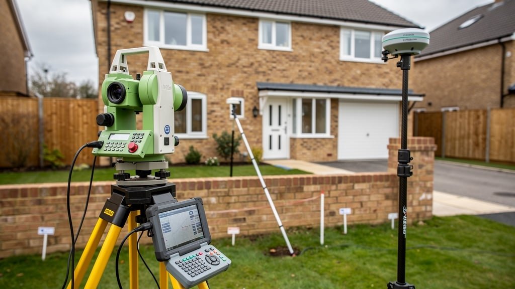
Global Positioning System (GPS) technology, more accurately called Global Navigation Satellite System (GNSS) when including other satellite systems like Russia's GLONASS and Europe's Galileo, has revolutionized land surveying. Modern GPS surveying equipment used by professional boundary surveyors can achieve remarkable accuracy through sophisticated techniques.
How GPS Boundary Surveys Work
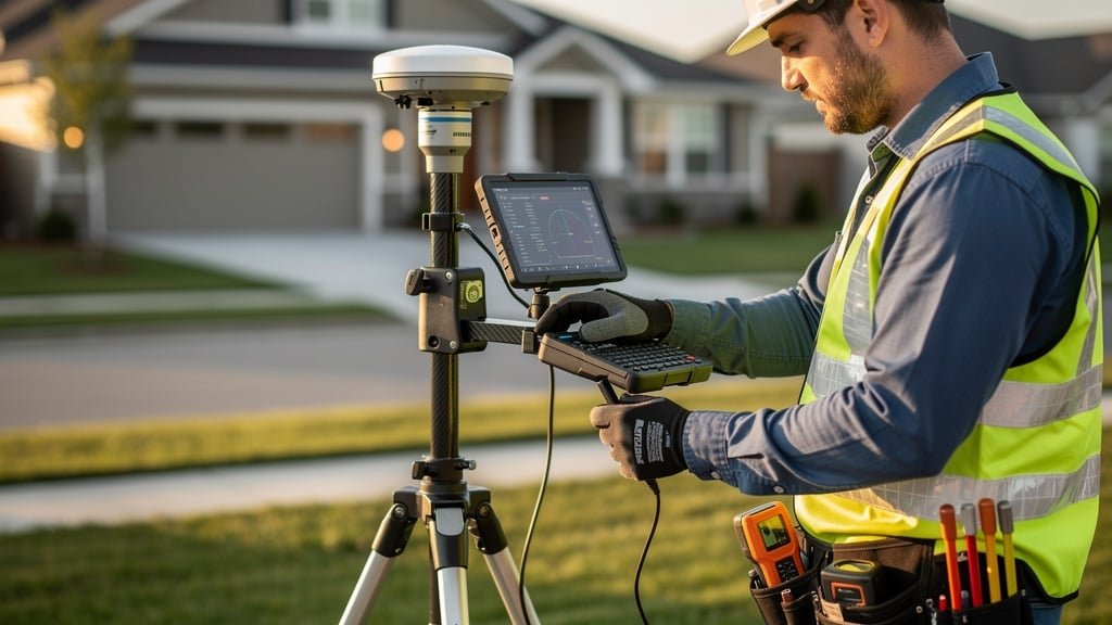
Professional GPS surveying for boundary determination uses Real Time Kinematic (RTK) GPS technology. This involves a base station GPS receiver set up at a known reference point, rover GPS receivers carried to points being surveyed, radio or internet link transmitting correction data from base to rovers, and sophisticated processing that corrects for satellite signal errors and atmospheric interference. RTK GPS can achieve horizontal accuracy of ten to twenty millimeters and vertical accuracy of fifteen to thirty millimeters under good conditions. This level of precision is more than adequate for boundary surveys, where we're typically trying to establish positions accurate to within a few centimeters.
Benefits of GPS for Boundary Determination
GPS technology offers numerous advantages for boundary surveying. It provides fast field data collection allowing surveyors to measure hundreds of points per day, works in all weather conditions unlike traditional optical instruments, maintains accuracy over long distances without cumulative errors, integrates seamlessly with digital mapping and CAD software, allows easy return visits to resurvey exact points years later, and provides coordinates in the National Grid reference system used by Ordnance Survey and Land Registry. For clients, this means faster survey completion, lower costs due to reduced field time, more comprehensive data capture covering the entire property, and highly accurate survey plans suitable for legal proceedings or Land Registry applications.
Limitations and Workarounds
Despite its power, GPS technology has limitations that experienced surveyors must work around. GPS requires clear sky visibility to receive satellite signals, so it doesn't work well under dense tree cover, inside buildings, or in urban canyons between tall buildings. Signal reception can be degraded near large metal structures or during solar storms. For these situations, land surveyors supplement GPS with traditional total station measurements, use laser scanners for building interiors and complex structures, combine multiple technologies to verify measurements, and extend GPS control networks using optical surveying from clear areas into obstructed zones.
Laser Scanning and 3D Surveying
Laser scanning technology, also called LiDAR (Light Detection and Ranging), has become increasingly important for complex boundary surveys, particularly where buildings and structures are involved.
How Laser Scanning Works
A laser scanner emits millions of laser pulses per second in multiple directions. Each pulse bounces off objects and returns to the scanner. By measuring the time taken for each pulse to return, the scanner calculates the distance to each point. Combined with the direction each pulse was sent, this creates a three-dimensional point cloud with millions of precisely measured points representing every surface visible from the scanner position. Modern scanners can capture up to one million points per second with accuracy of two to five millimeters at ranges up to one hundred meters.
For boundary surveys, laser scanning is particularly valuable for capturing detailed measurements of buildings near boundaries, walls and fences with complex geometry, historic boundary features with intricate details, sites with numerous features requiring measurement, and properties where visual documentation is needed alongside measurements. The resulting point cloud can be viewed as a three-dimensional model, with measurements extracted digitally without returning to site.
Applications in Boundary Dispute Resolution
Laser scanning technology provides unique benefits for resolving boundary disputes. It creates comprehensive visual records of boundary features showing their exact condition at a specific date, measures complex structures like bay windows or chimneys that might encroach across boundaries, documents historic boundary walls or hedges in detail before alterations or removal, provides evidence for court proceedings showing exact positions of disputed structures, and allows measurements to be extracted years later without resurveying. We recently used laser scanning in a complex boundary dispute where a client's neighbor claimed their garden wall had been moved. The scan showed every brick in the wall and proved it matched the position shown in photographs from ten years earlier, resolving the dispute without court proceedings.
Digital Mapping and CAD Technology
The data captured by GPS and laser scanners must be processed, analyzed, and presented clearly. Modern digital mapping and Computer Aided Design (CAD) software is essential for creating professional boundary survey plans.
Creating Modern Survey Plans
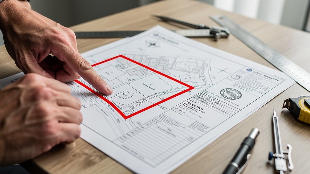
Professional land surveyors use sophisticated CAD software to process field survey data into accurate plans. The workflow includes importing GPS coordinates and laser scan point clouds into CAD software, cleaning and processing the data to remove errors and unwanted points, creating accurate two-dimensional and three-dimensional drawings showing all survey features, overlaying historic maps and title plans for comparison, adding annotations, dimensions, and explanatory notes, and generating final plans at appropriate scales for different purposes. Modern CAD software allows us to create plans that clearly show the relationship between legal boundaries shown on Land Registry title plans, historic boundaries shown on old maps, physical boundaries measured on the ground, and our expert opinion on where the legal boundary most likely lies. This clarity is invaluable for helping property owners understand boundary positions and for presenting evidence in legal proceedings.
Geographic Information Systems (GIS)
Geographic Information Systems (GIS) software takes digital mapping further by managing spatial data in database form. For boundary surveying, GIS allows integration of multiple data sources including Ordnance Survey mapping, Land Registry title plans, historic maps from multiple periods, aerial photographs, site survey measurements, and documentary evidence about boundaries. GIS analysis can reveal patterns and relationships that might not be obvious from individual maps, helping surveyors form opinions about likely boundary positions based on all available evidence.
Drone Technology and Aerial Surveying
Unmanned Aerial Vehicles (UAVs), commonly called drones, have become valuable tools for certain types of boundary surveys, particularly for larger properties or sites where ground access is difficult.
Drone Surveying Capabilities
Professional survey drones equipped with high-resolution cameras and GPS can capture detailed aerial photographs of properties showing boundary features from above, create orthophotographs (geometrically corrected aerial photos that can be measured), generate three-dimensional terrain models showing ground levels and topography, survey large areas quickly and cost-effectively, and access difficult terrain like steep slopes or wetlands safely. For boundary disputes involving rural properties, land with complex topography, or large estates where walking all boundaries would be time-consuming, drone surveys provide valuable supplementary data.
Limitations of Drone Surveying
While useful, drone surveying has important limitations for boundary determination. Drones cannot achieve the same accuracy as ground-based GPS for individual points, struggle to capture detail under tree canopy or inside structures, require Civil Aviation Authority permissions and landowner consent to fly, and may face restrictions in urban areas or near airports. Drone surveying works best as a complement to traditional ground surveying rather than a replacement. We use drones to provide context and overview, while ground-based GPS and total stations capture the precise boundary point measurements needed for legal evidence.
Total Stations: The Workhorse of Modern Surveying
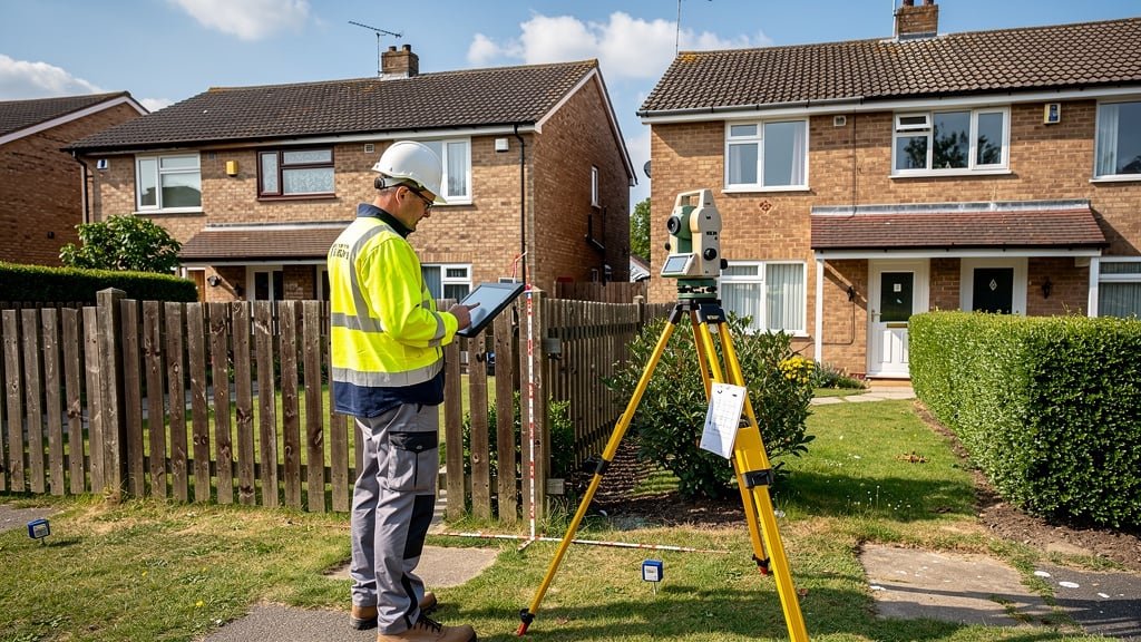
Despite newer technologies, electronic total stations remain essential tools for boundary surveyors. Total stations combine electronic distance measurement with digital angle measurement in a single instrument that can measure both horizontal and vertical positions of points with millimeter accuracy.
When Total Stations Excel
Total stations are particularly valuable for surveying in locations where GPS doesn't work well like dense urban areas, under tree canopy, or inside buildings, measuring relative positions between nearby points with extreme precision, setting out new boundary markers at calculated positions, checking and verifying GPS measurements, and traversing (extending survey networks through areas without GPS coverage). Modern total stations can operate robotically, with a single surveyor controlling the instrument remotely while holding the prism at points to be measured. This speeds up field work and reduces costs while maintaining high accuracy.
Software for Boundary Evidence Analysis
Beyond creating survey plans, specialized software helps boundary surveyors analyze evidence and form opinions about likely boundary positions.
Historic Map Analysis Tools
Software tools allow surveyors to overlay and compare historic maps from different periods, georeferencing old maps to modern coordinate systems for accurate comparison, measure features on historic maps to compare with modern surveys, track how boundaries have changed or remained consistent over time, and generate reports showing analysis of historic evidence. This technology helps us use historic Ordnance Survey mapping, old estate plans, and conveyance plans as evidence for boundary positions, which is often crucial in dispute resolution.
Statistical Analysis and Least Squares Adjustment
Professional survey software includes statistical tools for analyzing measurement quality. Least squares adjustment processes redundant measurements to calculate the most likely true positions of surveyed points, identifies measurements with potential errors for checking, calculates confidence intervals showing measurement uncertainty, and generates quality reports demonstrating survey reliability. For court evidence or Land Registry applications, demonstrating that surveys meet professional accuracy standards is important, and these statistical tools provide that proof.
Integration with Land Registry Systems
Modern surveying technology integrates seamlessly with HM Land Registry digital systems, which is particularly important when applying for determined boundaries or updating title plans.
Digital Plan Submission
Land Registry accepts digital survey plans in specific formats. Professional boundary surveyors prepare plans that meet Land Registry's technical specifications for digital plans, include proper georeferencing to the National Grid, show all required information for determined boundary applications, and format correctly for upload to Land Registry's digital systems. This streamlined digital process makes it easier and faster to register accurate boundaries officially.
The Human Element: Technology Requires Expertise
While modern technology provides powerful tools, it's crucial to understand that technology alone doesn't resolve boundary disputes. The most sophisticated equipment in the world is useless without the expertise to use it properly and interpret results correctly.
Why Professional Expertise Matters
Experienced RICS-accredited boundary surveyors bring essential skills including knowing which technology is appropriate for each specific situation, understanding how to combine multiple data sources and technologies, recognizing when measurements might be affected by errors or limitations, interpreting technical survey data in the context of legal boundary principles, and presenting complex technical information clearly for clients, solicitors, and courts. Technology provides the measurements, but professional judgment determines what those measurements mean for boundary positions. Our surveyors have decades of experience using the latest technology to help resolve boundary disputes throughout England and Wales.
Cost and Value of Modern Surveying Technology
Clients sometimes wonder whether modern technology makes boundary surveys more expensive. The reality is that technology has made surveys more affordable while improving accuracy.
How Technology Reduces Costs
Modern equipment reduces costs by allowing faster field data collection (less time on site means lower costs), enabling one surveyor to do work that previously required a team, reducing the need for return visits through comprehensive first-visit data capture, lowering errors and rework through improved accuracy, and making it easier to provide additional analysis or detail without resurveying. A boundary survey that might have taken a week of field work with traditional methods can now be completed in a day or two with GPS and laser scanning, with the rest of the time spent on analysis and report preparation rather than physical measurement.
Future Developments in Surveying Technology
Surveying technology continues to evolve rapidly, with several developments likely to further improve boundary dispute resolution in coming years.
Emerging Technologies
Technologies on the horizon include artificial intelligence for analyzing patterns in historic maps and documents, augmented reality systems for visualizing boundaries on site, improved satellite positioning with new GNSS constellations, mobile laser scanning from vehicles for surveying long boundaries quickly, and enhanced integration between survey data and legal property databases. These developments will make it even easier and more cost-effective for property owners to obtain definitive evidence about their boundaries.
Conclusion
Modern surveying technology has transformed boundary determination from an approximate art to a precise science. GPS, laser scanning, digital mapping, drones, and sophisticated software allow professional boundary surveyors to measure property boundaries with accuracy of millimeters, create comprehensive documentation of boundary features, integrate historic evidence with modern measurements, and present clear, reliable evidence for resolving disputes. However, technology is only as good as the professionals using it. RICS-accredited surveyors with expertise in both the technology and the legal principles of boundary determination are essential for getting reliable results.
At My Boundary Dispute Surveyors, we invest in the latest surveying technology and ensure our land surveyors are trained in its effective use. Whether you're facing a boundary dispute, planning building work near boundaries, or buying property where boundary certainty matters, our combination of advanced technology and professional expertise provides the evidence you need for confident decision-making.
Need a High-Precision Boundary Survey?
Our surveyors use the latest GPS, laser scanning, and digital mapping technology to provide accurate boundary surveys backed by professional expertise. Get definitive evidence about your property boundaries with modern surveying technology.
Frequently Asked Questions
How accurate is GPS for boundary surveying?
Professional RTK GPS used by qualified surveyors achieves accuracy of ten to twenty millimeters horizontally, which is more than adequate for boundary determination. This is far more accurate than traditional methods and provides reliable evidence for legal proceedings.
Is modern surveying technology more expensive than traditional methods?
No, modern technology actually reduces costs by allowing faster field work and more comprehensive data capture. A survey that might have taken a week with traditional methods can now be completed in a day or two, with the rest of the time spent on analysis rather than measurement.
Can laser scanning work in all weather conditions?
Laser scanners work well in most conditions but heavy rain can interfere with laser returns. GPS works in all weather. Professional surveyors choose appropriate technology for conditions and can combine multiple methods to ensure comprehensive coverage.
Do I need the most advanced technology for my boundary survey?
The technology used should match your needs. Simple boundary questions might only need GPS and total station measurements. Complex disputes involving buildings and structures benefit from laser scanning. Experienced surveyors recommend appropriate technology for each situation.
How long do survey measurements remain valid?
The measurements themselves remain accurate indefinitely—physical distances don't change. However, boundary features might alter over time. Survey data is usually considered reliable for several years, though disputes arising long after a survey may benefit from verification measurements.
Is technology replacing the need for boundary surveyors?
No, technology enhances what surveyors can do but doesn't replace their expertise. Interpreting measurements in the context of legal boundary principles, analyzing historic evidence, and forming professional opinions all require experienced qualified surveyors.